From Valentine, ref. 1
The Miller Plan
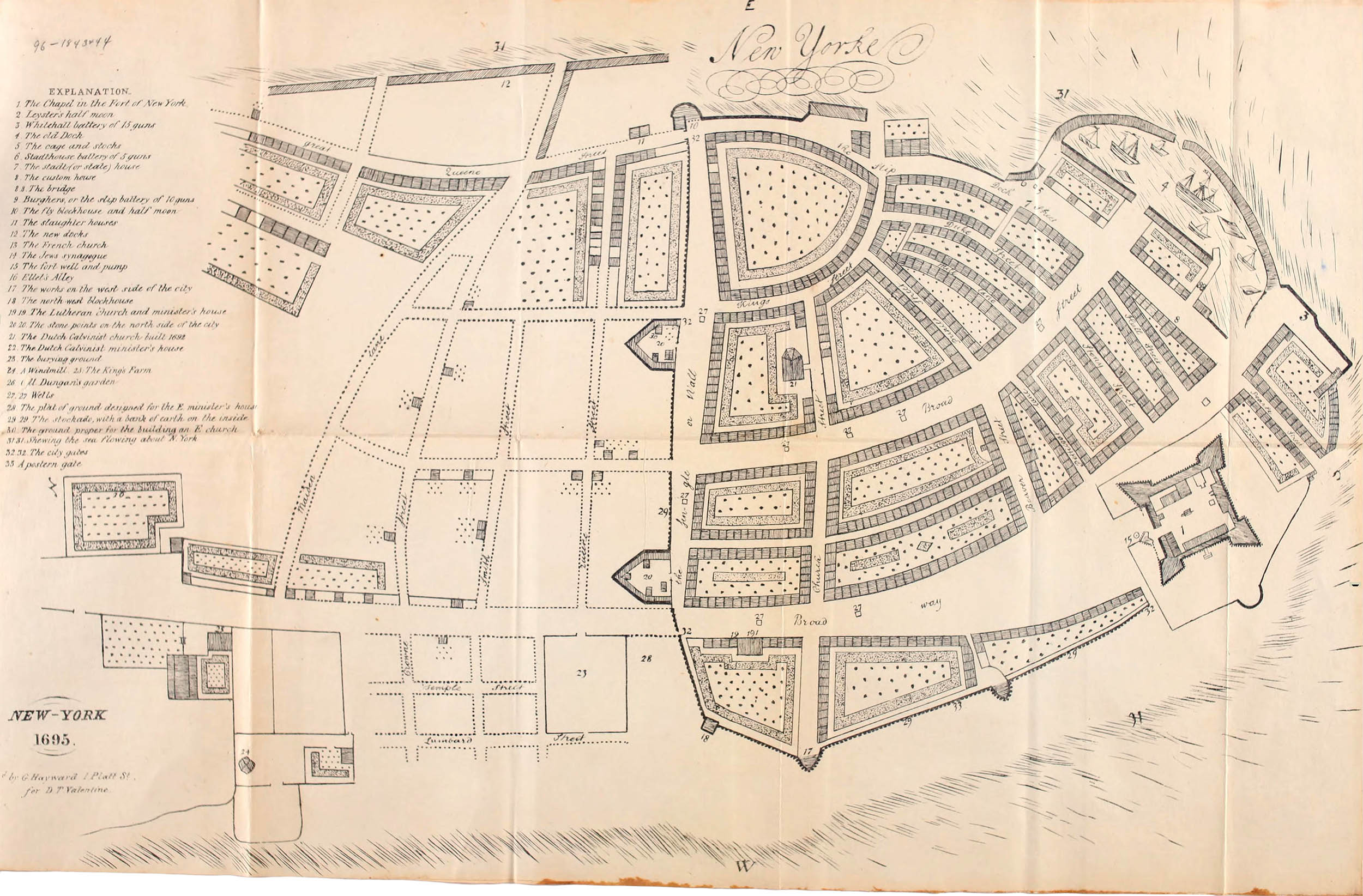
New Yorke
John Miller, 1695
Initially New York was indistinguishable from New Amsterdam. By the 1670s, however, the English governors began to make their own improvements to the city. In the 1675 the canal (Heere Gracht) was filled in and the wooden pier was replaced with the Great Dock – a stone pier surrounded by a breakwater.
As trade increased so too did the population: from some 3000 in 1680 to nearly 5000 by 1700. To accommodate this increase “water lots” on the East River shore were offered to those who would fill them in and build houses, new streets were laid out in 1691, 1694 and 1700 and finally, in 1694 the wall was torn down due to the “Incroachment of Buildings.”
Despite the removal of the wall virtually the entire city – now some 750 buildings – were still tightly clustered south of present-day Fulton Street. As Sarah Kemble Knight wrote in 1704:
“The Cittie of New York is a pleasant, well compacted place, situated on a Commodius River wch is a fine harbour for shipping. The Buildings Brick Generaly, very stately and high, though not altogether like ours in Boston. The Bricks in some of the Houses are of divers Coullers [diverse colors] and laid in Checkers, being glazed look very agreeable.”
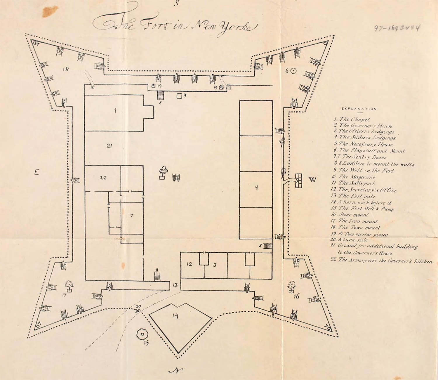
The Fort in New Yorke. From Valentine, ref. 1
The Rev. John Miller (1666 – 1724) was appointed the chaplain of the fort’s two companies of grenadiers in 1692 at the age of 26. He arrived in New York in June and spent three years as the sole Episcopal clergyman in the provence – a period he later described as “vexatious.” 2
On his return voyage to England in June 1695 his ship was captured by French privateers and he threw his notes and drawings overboard lest they “should have given Intelligence to an Enemy to the ruine of the Province.” After imprisonment in France he returned to England were he prepared an 14 × 10" ink on paper manuscript map of the city and a 6 × 8" map of the fort entirely from memory.
Through some unknown provence his manuscripts, including the maps, ended up with the antiquarian George Chalmers. They were subsequently purchased by the British Library in 1845.3 The example here, a lithograph by George Hayward, was published in Valentine’s 1842–43 Manual.1
Miller’s map included 33 referenced locations, including the batteries, the great Dock, the King’s Farm and not surprisingly, all of the churches in the city (including the first proposed location of the Trinity Church). It was the first map to show the street grid north of the wall in any detail.
26 January 2014
1. Valentine, D.T. (ed). Manual of the Corporation of New York. New York: William Bryant, 1843 (online).
2. Palsits, Victor (ed). New Yorke Considered and Improved A.D. 1695. Cleveland: Burrows Brothers, 1903 (online).
3. British Library Additional MS. 15,490.p.7. “A plan of New York; drawn, in 1695, by John Miller.”