The Castillo Plan
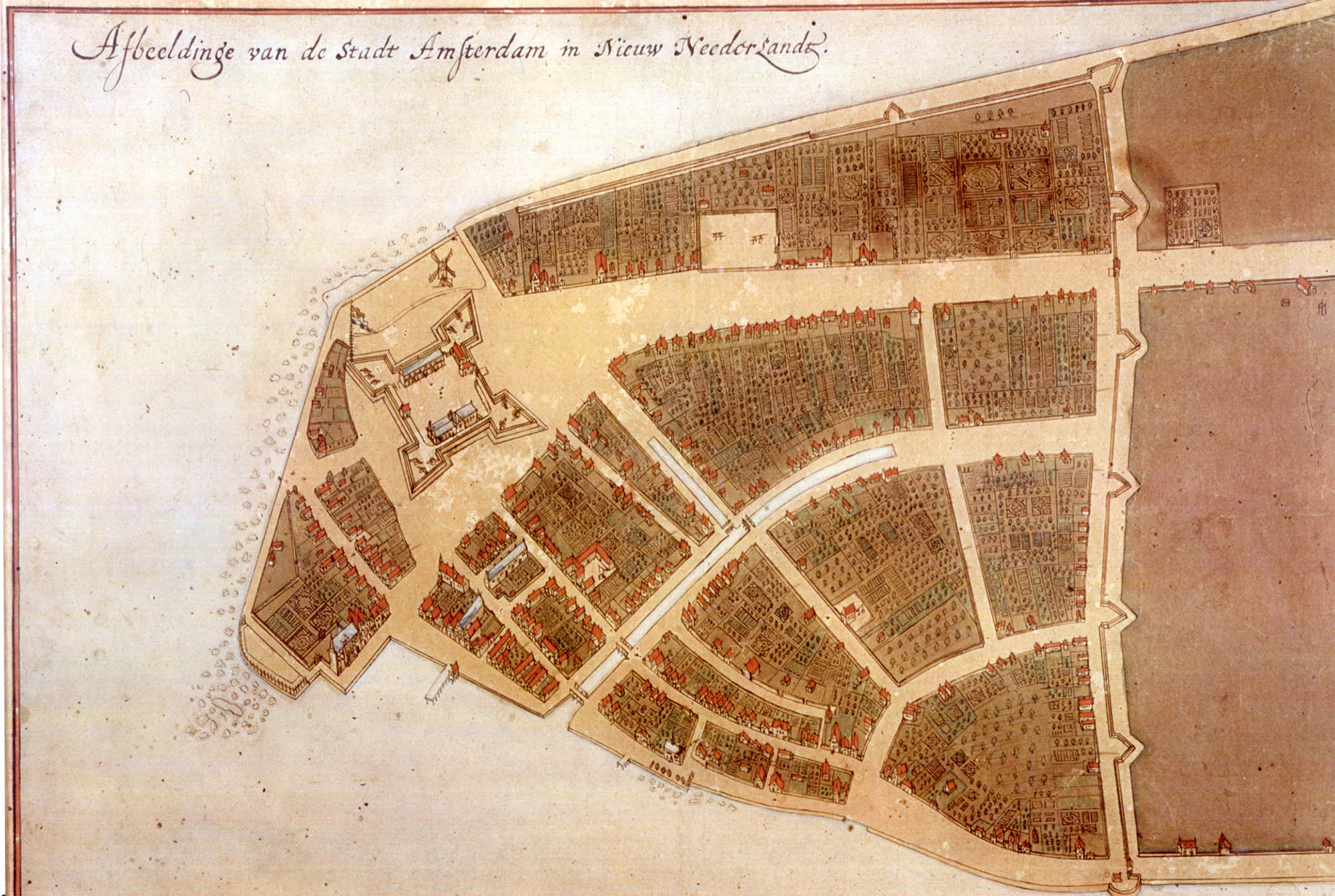
Afbeeldinge van de Stadt Amsterdam in Nieuw Neederlandt
(Picture of the City of Amsterdam in New Netherland)
Jacques Cortelyou/Anonymous, ca.1665
To safegaurd Dutch interests in New Netherland Willem Verhuls, the second Director-General the Dutch West India Company (WIC) built Fort Amsterdam in 1625 on the southern tip of Manhattan Island at the juncture of the East and Hudson rivers to, as Adriaen Van der Donck wrote, “possess all the lands comprehended between them as round about them…” 1
The fort served as military outpost as well as an administrative and commercial center. After the third WIC director Peter Minuit famously "purchased" Manhattan Island from the Lenape for 60 guilders in 1626 the company began relocating settlers to the area around the citadel forming the town of New Amsterdam.2
The town slowly grew with a mixture of not only Dutch settlers but Walloon, Huguenot, Frisian and English, and later African slaves and Ashkenazic and Sephardic Jews. The population was 270 in 1630, perhaps 400 in 1638 and nearly 700 by the time Peter Stuyvesant, the seventh and last director, arrived in 1648.
Stuyvesant, among other things, set out to turn New Amsterdam into a proper Dutch town. He widened and lengthened streets, turned the refuse stream into a gracht (canal), built a pier and in 1653 constructed a “high stockade and small brestwork across the northern frontier” [now Wall Street]. All of this required surveys and maps which the Dutch were remarkably proficient at in the 17th century.
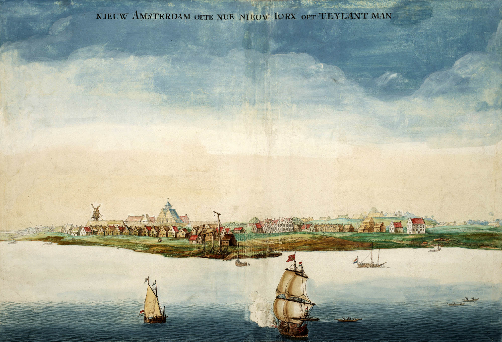
Johannes Vingboons, View of New Amsterdam/New York, 1664. Library of Congress
Jacques Cortelyou (ca.1625 – 1693) arrived in New Netherland from Utricht in 1652 and was commissioned by the provisional government as the surveyor general in 1657. On 7 June 1660 he was directed to survey and prepare a plan of New Amsterdam. Elaborating on several previous surveys he finished the task by October when his survey, along with a census prepared by Nicasius De Sille, was sent to the WIC directors in Amsterdam.
Cortelyou’s original survey is now lost but sometime around 1665 a 18 × 25" ink and watercolor manuscript map was prepared from it by an anonymous draftsman.
The manuscript ended up with the cartographer Johannes Blaeu (of Atlas Major fame) who bound it into an atlas and sold it to Cosimo de’ Medici, Grand Duke of Tuscany. The map was rediscovered in the de’ Medici's Villa di Castello near Florence in 1900, hence its Italian name – the Castello Plan. It is now in the Biblioteca Medicea-Laurenziana.
The bird’s-eye view shows everything from Fort Amsterdam at what is now the site of the US Customs House to the Stockade (and a few buildings outside the fortification). It includes some 15 streets and 300 buildings as well as agricultural spaces. It is the earliest known plan of the city.
In 1916 the historian I. N. Phelps Stokes and the artist John Wolcott Adams prepared a “redraft” of the Plan. Stokes was the first to compare the Plan with the De Sille List and remarkably he was able to not only identify nearly all of the 300 or so buildings and lots shown on the Plan but determine their owners as well – essentially turning the Plan into a cadastral map. This was covered in Joycean-like detail in his Iconography.3
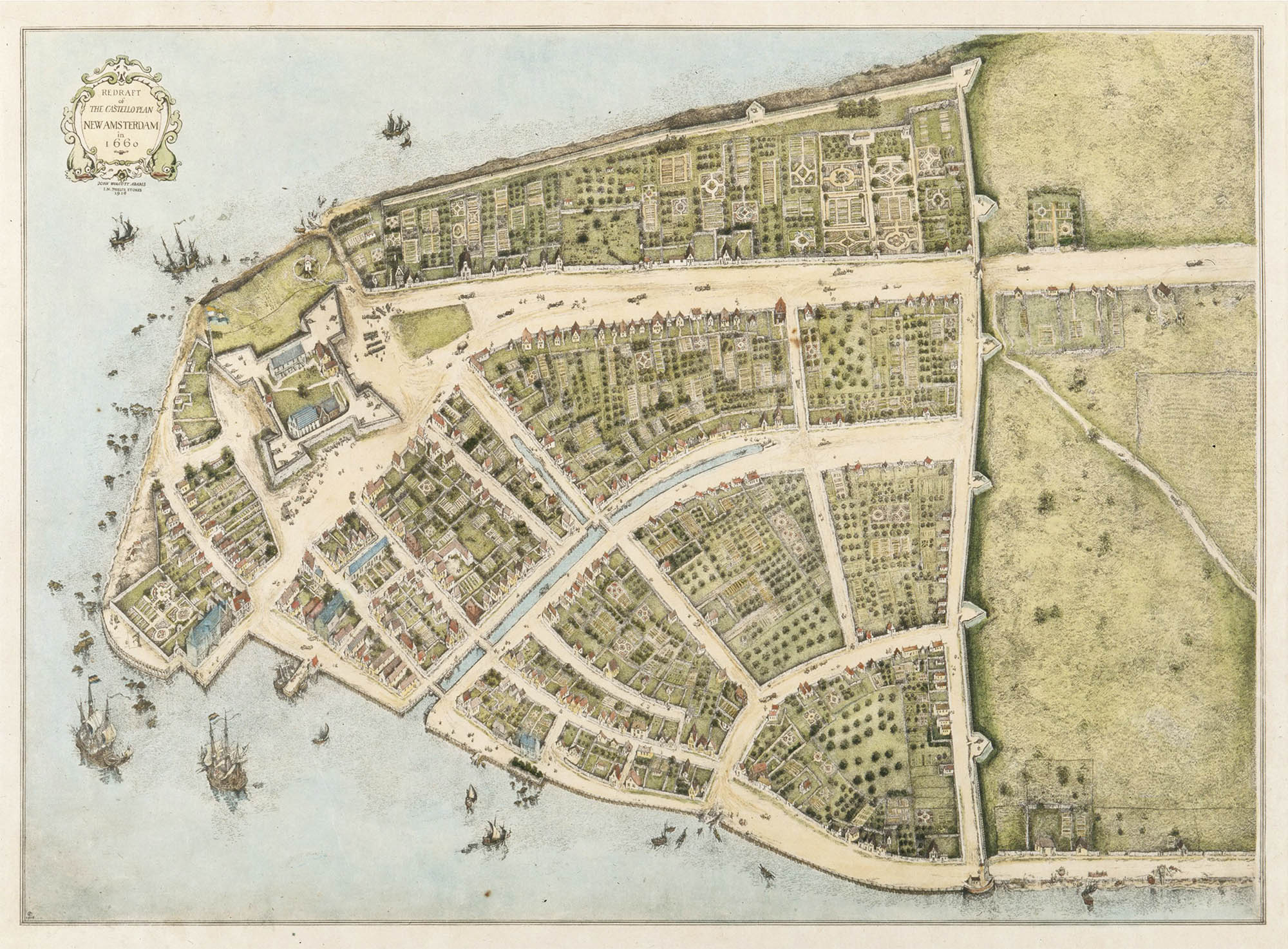
Redraft of the Castillo Plan. Wikimedia Commons
More recently, Peter Ekamper, a senior researcher at the Netherlands Interdisciplinary Demographic Institute, created an interactive geo-referenced map using this information:4
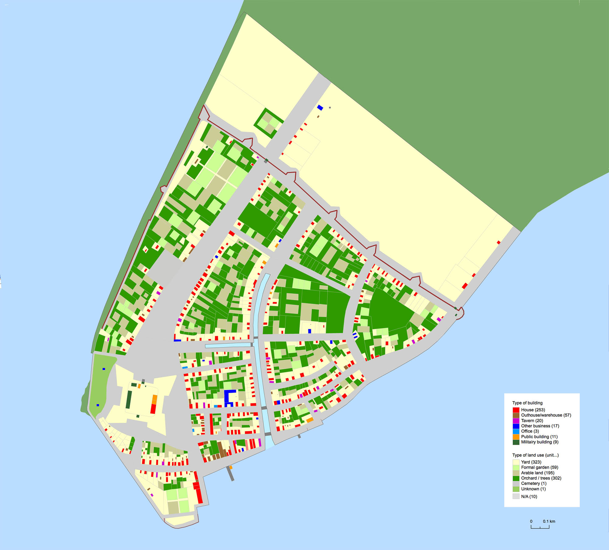
Digital Redraft of the Castillo Plan. Peter Ekamper
20 June 2013
1. See van der Donck, Adriaen. A Description of New Netherland. Lincoln: University of Nebraska Press, 2008 (WorldCat).
2. For more about the town see the New Amsterdam History Center. 3D modeling data is available on their workspace site.
3. Stokes, I. N. Phelps. The Iconography of Manhattan Island, 1498–1909. New York: Robert Dodd, 1915–1928. (6 vol) (online).
The Castello Plan: v2, 209–348
The De Sille List: v2, 349–351
4. Peter Ekamper, Digital Redraft of the Castillo Plan.